Today’s ride turned out to be more epic than I’d planned.
The route seemed fairly straightforward. Long stretch out on the A-road, then turn off, a fairly long and grinding climb, and turn back for home and it was largely all down hill on the way back.

Ahead of this one I’d deliberately thrown in the climb – that wasn’t unexpected. I knew I would be climbing up towards Oakenclough, and the climb itself was about 5km at 3%. The climb would hit around 14km and finish around 20km, with a short descent half way up. All seemed ideal.

The ride out to the climb was fairly uneventful.
With the UK pubs now back open, I had expected to find plenty of full car parks. Not so. Many pubs / restaurants that I passed were still very quiet.
I’d mistakenly thought the weather was worse than it was, and had decided to wear my long sleeve jersey and bib tights. By the time I hit the bottom of Oakenclough climb, I’d concluded that was a bad idea. Also, every other cyclist I saw – maybe 20 in total (though none on this hill) – were all in shorts. Whoops.


At the bottom of this one I had my sweat on.
Stuck behind a tractor hauling bails, I was a mixture of grass inhalation and perspiration.
Worse than the tractor was the several crapo diesel vehicles who were flooring it up the hill, spilling their toxic innards straight into my lungs. Pah.
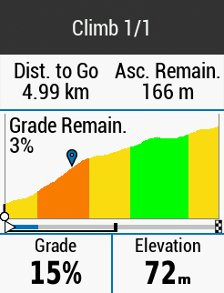
Fortunately, if you see things that way, the hardest part of this climb came very early. The steepest I saw was 15%, though it honestly didn’t seem that bad.
It would be super nice if the Garmin Climb Pro screen could be augmented with a bit of extra data. The two things I’d really like to see are my watts per kilo, and 3s power average. It sucks that I have to change screens to see this, and often if the climb has several turns, the GPS overlay screen takes over anyway. Bit of a UX fail there.

This climb was absolutely one of those where every time you turned a corner, the only way was up. Several continued inclines lay hidden behind rows of hedges and sheep fields.
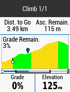
Over two thirds of the way up, a descending section appeared, giving time for a bit of respite – cheeky sip of water, blow my nose, that kind of thing. You can see in the right hand picture below the descent section, but taken from the other side – once back on the climb.


Getting towards the top, I got my weekly fill of my fly-based diet. Always plenty of little suckers about in those leafy sections. A good source of protein to see you through the final few meters.

And then wow, was the top completely unexpected.
Super quiet, and with absolutely stunning panoramic views of Lancashire and beyond.

I could see as far north as the Cumbria / Lake District, and as far east as the Pennines / Yorkshire. On the left was lovely views of the fells.
Even though it was a fairly overcast – and frequently seemingly soon to be rainy day, the views were obscured in all directions.
I stayed at the top for what must have been at least five minutes, just taking in the scenary.


And the descent was epic, too.
It’s rare that I feel confident enough to just let go and let the wheels rip under me. But today, with clear vision of the long road ahead, I hit 64kph, which I think is the fastest I’ve ever been on the bike so far.
That only translates to 40mph, but still, it felt fast.
And fun.

After this it was largely a case of trying to get home before the rain appeared. I got a text from home saying it was raining there, but miraculously it never arrived on my ride. And hasn’t rained since I got home.
Anyway, that was a great ride which I’d love to do again from the other direction. In reverse it’s steepest at the very end. Fun times. But worth it, I’m sure.
Tomorrow I have the true, new stage of the Watopia Tour de France to look forward too. Not looked at any of the previews of this, so it’s all going to be new to me. Perhaps I over did it on this one in prep for that. We shall see.
