This was one heck of a ride. Perhaps not the best day for it, either. I’d liken it to riding through the Trough of Bowland, with the caveat of whenever I’ve done that it’s been a sunny, or at least pleasant day.
Not today.

Whilst this route was expected to be long and tiring, I was happy enough with the elevation graph before setting off.
I like rides where the first half is uphill and the second half is largely down hill. Mentally this feels good when outdoors – I know there’s a half way point at which time the ride will get “easier”.
The biggest issue, which I kinda brushed under the carpet, would be around beating the weather.

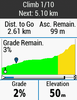
I wasn’t aware there were 10 climbs involved in this ride. At least I only found out at the point of setting off.
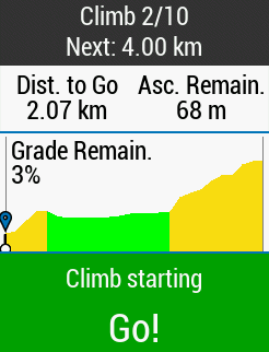
It was pretty much all down hill out of Preston and into Hoghton where upon the first climb of the day lay in wait.
After that climb I was kinda thinking maybe I shouldn’t have set off with my hood up. Sure, it keeps out the wind, but it also traps in the sweat, and I’d pushed perhaps a bit too hard (for a ride with 9 remaining climbs) on that initial effort.
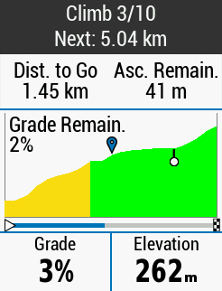
Anyway, after doing that climb I decided to go slightly off route to go photograph Hoghton Tower – a lovely local landmark. Check out that drive way.
Because the Tower was slightly off route, I got in a few extra meters of bonus climb heading back up from that to my route proper. Bonus meters would become a thing of regularity on this ride.
After leaving Hoghton I was heading up a road I’ve never travelled before. I believe I saw a sign here saying I’d entered the West Pennine Moors, but I can’t seem to find this anywhere on Google maps, so I may be wrong.
All I know is that this road would cut through basically barren countryside with, as best I recall, four of the first five climbs coming fairly steadily, one after the other.
None of these climbs were particularly killer. What was difficult was the wind. In particular the cross wind. I’ve never experienced anything like it. I was having to actively lean at a 20 to 30 degrees to my right in order to fight the vicious right to left cross wind. With open moors on either side, there was very little shelter and several times I was noticeably physically blown towards the edge of the road. Hairy stuff.

Perhaps the biggest mistake I made today was in leaving it too late to set off.
The weather forecast suggested a bit of rain up until about 1pm. Then from 1pm, it hinted at quite a lot of rain.
Sadly for me, the forecast was very accurate.
As the shots above show, the grey clouds were very much rolling in. Clad in my darkened sunglasses, I perhaps didn’t realise just how gloomy things were becoming. At the point I stopped above, it started spitting. Maybe I should have turned back…

Anyway, I didn’t turn back. Well, I kinda did, but only because I missed my turn off heading into Rivington.
As this was a new route to me, I ended up making three wrong turns. All of which cost me more climbing.
Heading into the Rivington climb proper, I was met with a really nice looking sight – quite a bit of litter in the bushes and stuff, sadly. But in many ways, it reminded me of the Trough of Bowland, albeit a smaller version.
The climb was decent, but my God, the wind was brutal.
So brutal in fact that on the descent I had to pedal to keep momentum. I’ve never experienced anything quite like it.
The views, I imagine, would be lovely on a nice day. Sadly the wind put me off stopping.

My route took me out of Rivington and down to Horwich, where I turned back on myself and cycled along the road, passed the lower reservoir with lovely views up to the tower on top of Rivington Pike.
After this I was due to cross over to Anglezarke Reservoir further north.
The first part of this went smoothly and I was greeted by this awesome curving descent. I went flying down there, tucked in behind a car which I think I put the fear of god into the driver.

The rain kicked in at this point, but I wasn’t yet drenched.
I crossed the reservoir via the road bridge, and then managed to take a wrong turn there. At this point, things went wrong.
Because the reservoirs are naturally in a basin, the only way back out is up and over.
My glasses had suitably coated in water during the descent, and I made an educated guess as to which turn to take. Sometimes I find the Garmin isn’t that helpful at less obvious junctions.
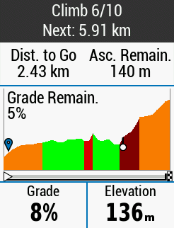
I could see I had the blood red portion of climb 6 still to go.
So, up a hill I went. It wasn’t as steep as I expected, but it was steep enough. Only, when I got to the top, the Garmin was telling me to pull a U-turn.
Strange, I thought, as I could see yet another steep climb directly ahead. It all felt right.
Alas, after a bit of bodging – during which I managed to end my ride (hence the two different sets of stats) – I managed to locate my proper route. And yes, I had to redo the climb… and it was harder. Quite a lot harder.


Again, at the top of Anglezarke climb I would loved to have stopped to take some photos. There were plenty of cars parked up, but by this point the rain had really started. Also, the climb wasn’t over yet, so no stopping for me.
On I went.
Getting wetter, and wetter.
Bearing in mind I had ~1 hour of riding left to get home, things weren’t looking brilliant.
Sometime after this I managed yet another wrong turn, followed about ten minutes later by another. Every wrong turn seemed to result in me doing more climbing.


Combining the wrong turns, knackering climbs, being soaking wet and cold, and the horrible wind … well, I just wanted to be back home.
So, unfortunately my motivation took a real dip, and any ideals of screenshots and photos went right out of the window.
Shame really, as the route itself could be a really good one on a nice day.
Anyway, I would plan to do this again for sure. It was most definitely harder than last week’s Lancaster ride, which is weird really because the calorie count is about the same.

